
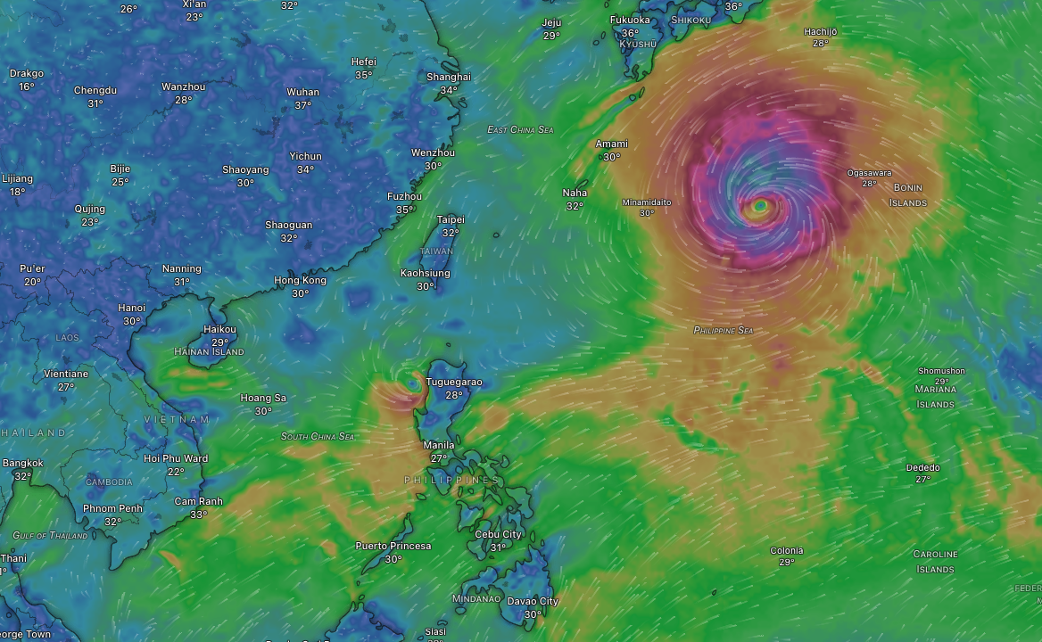
Tropical Storm Maymay (international name: Kujira) is the Philippines’ 13th tropical cyclone for 2026 and is now the dominant weather system bringing heavy rain and strong winds to Luzon. Expected to make landfall over Ilocos Sur or La Union on August 5, 2026, Maymay poses significant threats including flooding and landslides across Northern and Central Luzon. Understanding this storm system and its expected impacts can help residents prepare and stay safe during this critical weather event.
What’s Causing All This Rain?
1. Tropical Storm Maymay – The Current Rain Maker
Just as Luis was fading away, a new weather system took its place. Tropical Storm Maymay (international name: Kujira) is now bringing moderate to intense rain to Northern Luzon and Central Luzon. This storm represents the Philippines’ 13th tropical cyclone for 2026, and the second for August, coming shortly after Tropical Depression Luis.
Maymay intensified into a tropical storm, with six areas in Luzon placed under Tropical Cyclone Wind Signal No. 2. The storm is expected to make landfall over Ilocos Sur or La Union by Wednesday afternoon or evening (August 5), and afterwards will traverse the landmass of Northern and Central Luzon until Thursday.
2. Tropical Depression Luis and Its Aftermath
The initial rain event was caused by Tropical Depression Luis, which brought rain to several parts of the country starting August 3-4, 2026. This tropical cyclone and the southwest monsoon combination brought heavy to intense rain in some areas of Luzon, particularly affecting Northern and Central Luzon provinces.
Despite slight weakening over time, Tropical Depression Luis continued to dump rain in many areas through Monday, August 3. However, Luis has since weakened and is no longer the primary weather concern.
3. The Southwest Monsoon (Habagat) Effect
Beyond the tropical cyclones, the southwest monsoon is bringing scattered rain and thunderstorms to the Ilocos Region, Cordillera Administrative Region, Cagayan Valley, and Central Luzon. The monsoon pattern is a seasonal weather system that naturally brings moisture to western portions of the country during this time of year.
4. Enhancement from Typhoon Dolphin
Adding another layer to the complex weather picture, multiple low-pressure areas have formed inside the Philippine Area of Responsibility, causing significant rain in Central Luzon and Northern Luzon. Additionally, Typhoon Dolphin, which remains outside Philippine waters, is enhancing the southwest monsoon pattern, contributing to increased rainfall across Luzon.
What Areas Are Most Affected?
Current Rainfall Warnings (August 5-6)
Heavy to intense rain due to Maymay is hitting Northern Luzon and Central Luzon, raising concerns for floods and landslides. The following areas may be most affected by rain:
Heavy to Intense Rain (100-200 millimeters):
- La Union
- Pangasinan
- Benguet
- Zambales
Moderate to Heavy Rain (50-100 mm):
- Ilocos Sur
- Ifugao
- Mountain Province
- Tarlac
- Nueva Ecija
- Bataan
- Pampanga
- Bulacan
The heaviest rainfall is expected in Northern Luzon and parts of the Cordillera Administrative Region, where residents should be especially vigilant about flooding and landslide risks.
Weekly Weather Forecast: August 5-11, 2026
Today – Wednesday, August 5
- Condition: Tropical Storm Maymay approaching landfall
- Expected Rain: Heavy to intense (100-200 mm) in La Union, Pangasinan, Benguet, Zambales
- Wind: Strong to gale-force gusts, especially in coastal and mountainous areas
- Alert Level: Tropical Cyclone Wind Signal No. 2 active in select areas
- Advisory: Residents in Northern Luzon should prepare for deteriorating weather conditions immediately
Thursday, August 6
- Condition: Maymay crossing Northern and Central Luzon
- Expected Rain: Moderate to heavy (50-100 mm) continuing in previously affected areas
- Wind: Gale-force winds expected, particularly in mountain passes
- Forecast Development: Maymay expected to weaken back into a tropical depression by Thursday morning, and subsequently into a low pressure area by Thursday afternoon or evening
- Advisory: Continuous monitoring needed; road conditions may be hazardous
Friday, August 7
- Condition: Maymay expected to weaken to low pressure area; Southwest monsoon continues
- Expected Rain: Light to moderate scattered showers in Central and Southern Luzon
- Wind: Strong winds diminishing but continuing from southwest monsoon
- Visibility: Improving as the tropical cyclone moves away
- Advisory: Begin cleanup and assessment of storm damage; watch for remaining flood risks
Saturday-Sunday, August 8-9
- Condition: Southwest monsoon dominates weather pattern
- Expected Rain: Scattered to isolated showers mainly in afternoon/evening
- Wind: Moderate southwest winds
- Temperature: Gradually warming as system moves away
- Advisory: Weather conditions improving; good time for outdoor activities in afternoon hours
Monday-Tuesday, August 10-11
- Condition: Southwest monsoon weakening; fair weather expected
- Expected Rain: Isolated showers only, mostly in mountainous areas
- Wind: Light to moderate southwest winds
- Overall Pattern: Predominantly fair to partly cloudy
- Advisory: Return to normal activities; excellent conditions for outdoor plans
Important Safety Reminders
- Flooding Risk: The combination of tropical cyclones and monsoon rains creates significant flooding potential, especially in low-lying areas and areas with poor drainage.
- Landslide Warnings: Mountainous areas in Northern Luzon and the Cordillera region are at elevated risk for landslides due to heavy rainfall.
- Wind Safety: Strong to gale-force winds can damage structures, topple trees, and create hazardous driving conditions. Secure loose objects and avoid unnecessary travel during peak wind hours.
- Monitor PAGASA Updates: Wind Signal No. 2 means gale-force winds ranging from 62 to 88 kilometers per hour may affect these areas within approximately 24 hours. Stay updated with PAGASA bulletins for the latest alerts.
- Evacuation: If authorities issue evacuation orders due to flooding or landslide risks, comply immediately.
The rain currently affecting Luzon is not unusual for this time of year, but the combination of three weather systems—the remnants of Tropical Depression Luis, the newly-formed Tropical Storm Maymay, and the seasonal southwest monsoon—has created a particularly wet pattern. While the worst conditions are expected to pass by Thursday, residents should remain vigilant through the following week as the southwest monsoon continues its effects.
By understanding these weather systems and heeding PAGASA warnings, Luzonians can better prepare for and respond to the challenges posed by this wet weather period.
Sources
- Philippine Atmospheric, Geophysical and Astronomical Services Administration (PAGASA) – Official Philippine weather bureau
- GMA News Online – Major Philippine news network
- Rappler.com – Major Philippine news outlet
- The Manila Times – Philippine newspaper
- Philstar.com – Philippine news website
All information sourced from official weather advisories and trusted Philippine news outlets as of August 5, 2026